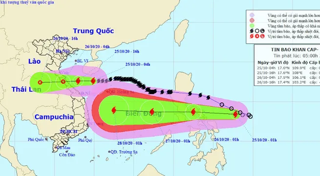
Eighth storm to hit provinces from Ha Tinh to Quang Tri in next 24 hours

As of 4am on October 25, the storm’s eye was about 17.6 degrees north latitude and 109.9 degrees east longitude, about 330 km east of provinces from Ha Tinh to Quang Tri.
The strongest winds in the area near the centre of the typhoon are blowing at 75-90kph (level 9), with gusts at level 11.
It is forecast that in the next 12 hours, the storm will keep moving west at a speed of 15-20km per hour and make landfall in provinces from Ha Tinh to Quang Tri before weakening into a tropical depression.
As of 4am on October 26, the tropical depression will be centred around 17.5 degrees north latitude and 106.1 degrees east longitude, right on the mainland from Ha Tinh to Quang Tri, packing winds of 40-50kph (level6) with gusts at level 8.
For the following 24-36 hours, the tropical depression will move west at a speed of 15-20km per hour, going further inland and devolving into a low pressure area.
By 4am on October 26, the centre of the low pressure area will be at around 17.4 degrees north latitude and 103.2 degrees east longitude, with the strongest winds near its eye falling to below 40 kph (below level 6).
The danger zone in the East Sea in the next 24 hours will be 15.5 degrees north latitude and 112.5 degrees east longitude. All boats operating in the danger zone are at high risk of being badly affected by gusts and tornadoes.
It is forecasted that in the Gulf of Tonkin and coastal areas from Quang Tri to Thua Thien Hue provinces, winds will gradually increase to level 6-7 and level 8 (with gusts at level 10) in the area near the storm’s eye on October 25.
The storm will result in rainfalls in the provinces from Nghe An to Thua Thien Hue. The disaster risk is forecasted at level 3.
Tags:


