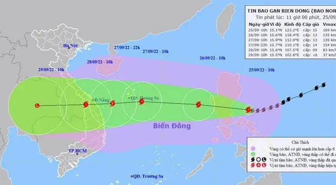
Storm at shock level 17 to hit East Sea in next 24 hours

The storm’s centre was about 300km east of Luzon Island (Philippines) at 7 am on September 25, with the strongest winds near the centre of the storm reaching level 15 (167-183 km per hour), with shock at level 17.
By 7am on September 26, the storm’s centre is projected to be 15.6 degrees north latitude and 118.9 degrees east longitude, about 800km East of the Hoang Sa (Paracel) Archipelago. The strongest winds in the area near the centre of the storm will be strong at level 12-13 (134-149km per hour), with shock at level 16.
Dangerous areas in the East Sea in the next 24 hours (strong winds of level 6 or higher, gusts of level 8 or higher): from 12.5 to 19.5 degrees north latitude and 115.5 degrees east longitude. All vessels operating in the hazardous zone are at high risk of being affected by strong winds, high waves and tornadoes, with disaster risk at level 3.
Over the following 24 to 48 hours, it is likely to continue moving west at a speed of about 20-25km per hour, tending to get stronger.
By 7am on September 27, it will be centred around 16.0 degrees north latitude and 113.4 degrees east latitude, about 190km East of Hoang Sa Island. The strongest winds in the area near the storm’s eye are expected to be at level 13 (134-149 km per hour), with shock at level 16. 48 to 72 hours from now, the storm will move quickly west-southwest at a speed of 25-30km per hour.
As of 7am on September 28, the storm’s centre will be located at 16.0 degrees north latitude and 113.4 degrees east longitude, over the mainland of Thua Thien Hue - Quang Ngai. The strongest winds near its centre will blow at level 8-9 (62-88km per hour), with shock at level 11.
Due to the influence of the storm, from about the afternoon of September 25, the eastern sea in the north and the middle of the East Sea/South China Sea, will be facing strong winds at levels 8-9; then level 10-11. 72 to 96 hours from now, the storm will move mainly to the west at a speed of about 20-25km per hour and is likely to weaken.


